FarSounder, Inc.
151 Lavan Street
Warwick, RI 02888
USA
T: +1 401 784 6700
FarSounder is the world leader in the design, manufacture, and sales of 3D Forward Looking Sonar [FLS] systems. FarSounder’s cutting-edge 3D FLS provides real-time imagery of what’s beneath of the waters ahead. These systems give mariners the security of safely navigating through challenging waters and promptly being alerted when objects are approaching from up to 1000 meters ahead. Operators are now able to detect hazards, shallow bottoms, and a variety of moving underwater obstacles before a dangerous situation occurs.

Radar, depth sounders, ECDIS, and electronics charts with GPS are missing an important piece of information: What is under the water in front of my ship right now? The FarSounder navigational sonar systems provide this missing piece of the puzzle. Your charts don't know what has changed on the ocean floor; your radar can't see through water; and your depth sounder only looks down.
Vessels can look ahead and navigate with confidence in unknown waters with FarSounder leading the way. FarSounder Sonars are used by all types of vessels in oceans and seas around the globe. Ships can navigate shallow waters comfortably and explore bays, new inlets and rivers safely.
This user-friendly technology is fully integrated with the Wärtsilä Sam NACOS Platinum bridge. Bridge crew have the convenience of seeing and controlling FarSounder 3D sonar from all work stations. It couldn’t be easier to monitor challenging waters ahead than with this seamless system.
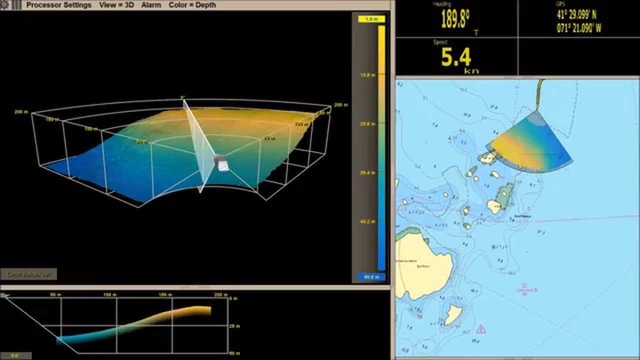
FarSounder sonar systems now include a new innovative technology called Local History Mapping (LHM)™. In addition to having the benefits of 3D real-time forward-looking sonar, this new capability builds a 3D map of the seafloor as you sail. This map is updated with every ping and is displayed as an overlay on top of your chart. When used together with the real-time sonar overlay, you can quickly see what lies ahead and what you’ve recently passed over. LHM capabilities are included as part of its standard navigation sonar software starting with SonaSoft™ 3.3.
Due to the unique performance characteristics of FarSounder’s forward-looking sonar systems, Local History Mapping™ is based on a bathymetric survey engine that was developed in-house from the ground up. The Company has also invested heavily in the database infrastructure associated with the storage and integration of large survey datasets. These investments will accelerate the release of additional bathymetric mapping capabilities.
One use for LHM’s real-time data: a vessel could perform a small survey covering the expected extents of the area over which the vessel is expected to swing. Displaying the survey as an overlay on top of an electronic nautical chart, makes it easy for the bridge crew to visualize the vessel’s current position. Operators would be able to orient the vessel relative to any features or obstructions found with the survey. It would assist even when the obstruction is not within the current field-of-view of the sonar’s real-time display.